About Us

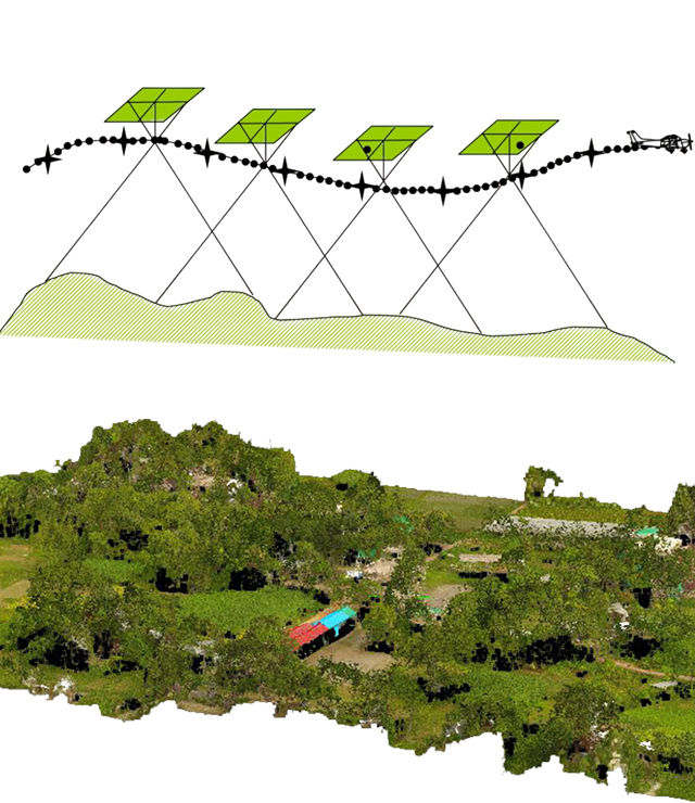
We’re specialized in GIS Mapping Remote Sensing and Smart Digital Survey Solutions.

Magpie Robin Bangladesh has built enduring client relationships based on consistent quality service. Over the year, it is growing as a progressive leader through hard work and strategically selected consulting wings that together bring multi-dimension of experience. Each wing has capabilities and success in delivering consulting solutions.

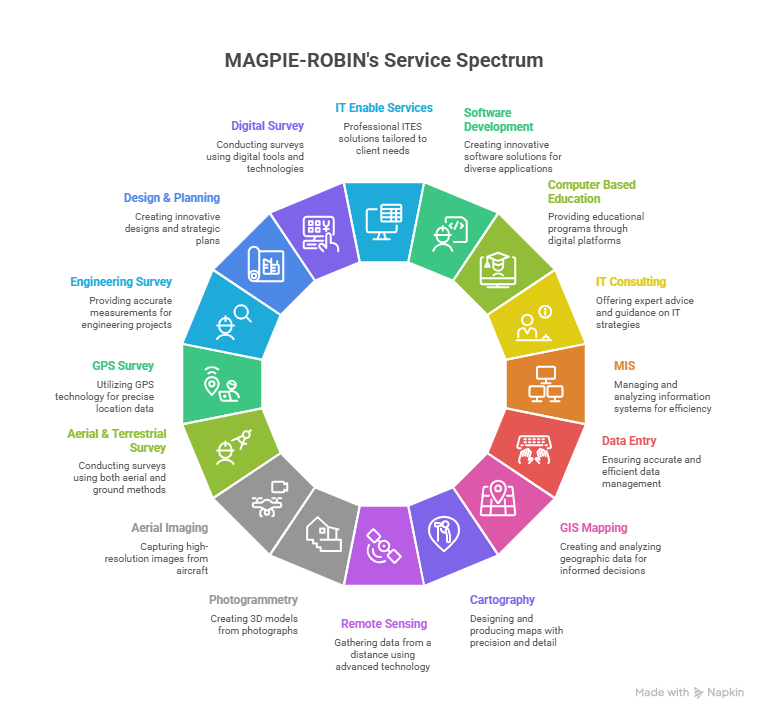
Magpie Robin Bangladesh provides professional IT enabled Geospatial (GIS), Information Technology (IT), Quantitative and qualitative surveying, Graphic design, Printing and Media Production consultancy & services in strict adherence to the highest ethical and technical standards. We understand that each of our client's needs are unique, however they all require timely, technically sound and cost-effective solutions. Our standard business practice is to work with each client to clearly define project scope and requirements and develop a solution that is right on target. We assist our clients through consulting, planning, design and implementation of viable and practical projects & programs that are delivered on time and on budget.

Our commitment to our clients is strong and lasting. Our goal is to continue to improve and diversify our range of services through the development and training of our staff and by constantly upgrading our technology resources. We want to build on our hard-earned reputation for quality services and to strive toward ever higher standards.

We Provide

We deliver professional GIS mapping, remote sensing, and smart digital survey solutions — turning spatial data into actionable insights.

  • What we do
  • Our Mission
  • Social impact

We offer a full spectrum of geospatial and surveying services: high-precision GIS mapping, aerial and terrestrial photogrammetry, remote sensing analysis, GPS and engineering surveys, and hydrological and environmental assessments. In addition, we provide digital survey solutions, cartography, mapping for infrastructure and urban planning, socio-economic and baseline surveys, and feasibility studies. Our team supports clients through consulting, design, data processing, visualization, and implementation — ensuring projects are delivered on time, on budget, and to the highest technical standards.

  • GIS Mapping & Spatial Database Development
  • Remote Sensing Image Analysis & Interpretation
  • Aerial Photogrammetry & Aerial Imaging
  • Terrestrial & GPS Surveying (Engineering Survey)
  • Cartography, Map Design & Visualization
  • Hydrological, Environmental & EIA Studies
  • Socio-Economic & Baseline Surveys
  • Infrastructure, Urban & Regional Planning Support
  • Data Processing, GIS Analysis & Thematic Mapping
  • MIS, IT Consulting, Software Development & Training

At Magpie Robin Bangladesh, our mission is to deliver innovative, reliable, and sustainable technology solutions that help our clients achieve excellence in every project. We are committed to precision, progress, and partnership in all that we do.

  • Provide high-quality GIS Mapping, Remote Sensing, and Digital Survey solutions.
  • Ensure data accuracy, reliability, and timely project delivery.
  • Support sustainable development through technology and innovation.
  • Empower organizations with data-driven insights for better decision-making.
  • Continuously enhance our technical expertise and professional standards.
  • Build long-term client relationships based on trust and performance.
  • Contribute to national and global growth through ethical and responsible practices.

At Magpie Robin Bangladesh, we believe that technology should not only drive progress but also create a positive difference in society.
Our work goes beyond business — it contributes to sustainable development, community empowerment, and environmental awareness.

  • Promoting digital literacy and IT-based education among youth and students.
  • Supporting sustainable urban and rural planning through accurate geospatial data.
  • Encouraging responsible use of technology for environmental conservation.
  • Creating employment and skill development opportunities in the IT and GIS sectors.
  • Assisting government and non-government projects aimed at social and economic development.
  • Enhancing disaster management and climate resilience through GIS and remote sensing solutions.
  • Upholding ethical practices and inclusivity in all our projects and partnerships.
Area of Expertise

GIS Mapping, Cartography, Remote sensing, Photogrammetry, Aerial Imaging

MAGPIE-ROBIN provides professional IT Enable Services (ITES), Software development, Computer based education, IT Consulting, MIS, Data Entry, GIS Mapping, Cartography, Remote sensing, Photogrammetry, Aerial Imaging, Aerial & Terrestrial Survey, GPS Survey, Engineering Survey, Design & Planning, Digital Survey, Hydrological survey, Socio Economic Survey, Environmental Survey, EIA & EIS, Base line survey, Infrastructure development, Urban, Rural & Regional Planning, Urban Design, Development Planning, Master Planning, Strategic Development Planning, Feasibility Study, Research and GIS, MIS & IT Training, consultancy & services in strict adherence to the highest ethical and technical standards. We understand that each of our client's needs are unique, however they all require timely, technically sound and cost-effective solutions. Our standard business practice is to work with each client to clearly define project scope and requirements and develop a solution that is right on target. We assist our clients through consulting, planning, design and implementation of viable and practical projects & programs that are delivered on time and on budget.

Organizations We’ve Worked With

BARC NWO newlogo wag INNO CEGIS INS INS INS INS INS INS